WATERSHED GEOSCIENCE
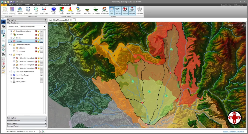
Fluvial Engineering specializes in providing comprehensive watershed geoscientific analysis, utilizing advanced hydrological forecasting techniques. They employ state-of-the-art software from CivilGeo, which incorporates the Hydrologic Modeling System (HEC-HMS) designed by the US Army Corps of Engineers Hydrologic Engineering Center. This powerful tool simulates the complete hydrologic processes of dendritic watershed systems, enabling precise modeling and analysis. Fluvial Engineering’s expertise in applying HEC-HMS allows them to accurately predict and manage water flow and distribution within watersheds, which is critical for effective water resource management and planning.
The CivilGeo GeoHECHMS software enhances this capability by offering graphical interaction with all HEC-HMS model elements, facilitating experimentation with geoscience data and climate scenarios through automated workflows. This integration enables Fluvial engineers and geoscientists to refine their models and predictions with high efficiency and accuracy. Upon completion of the HEC-HMS models, the results are exported to AutoCAD, MicroStation, and ArcGIS for further analysis and communication with clients. This seamless transition between platforms ensures that the data is accessible and actionable, supporting informed decision-making and effective communication of complex hydrological information.
STREAM CROSSING ENGINEERING
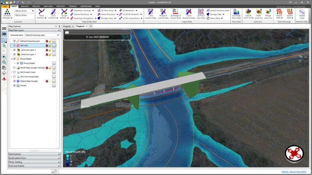
Fluvial Engineering excels in providing river hydraulic analysis for stream crossing design using advanced software from CivilGeo, which incorporates the industry-standard River Analysis System (HEC-RAS) developed by the US Army Corps of Engineers Hydrologic Engineering Center. This sophisticated tool enables the performance of one-dimensional steady flow, one and two-dimensional unsteady flow calculations, sediment transport and mobile bed computations, as well as water temperature and quality modeling. By leveraging HEC-RAS, Fluvial Engineering ensures precise and comprehensive analysis, crucial for the effective design and management of stream crossing structures.
Our clientele undertakes numerous projects involving stream crossing structures, which facilitate the passage of people, vehicles, and resources across streams and other watercourses. These crossings can take various forms, such as bridges, culverts, pipelines, and diversion structures. The design and construction of these stream crossings have significant environmental implications, particularly concerning the health of stream ecosystems and the mobility of aquatic species. CivilGeo GeoHECRAS software enhances this process by offering graphical interaction with all HEC-RAS model elements, allowing for experimentation with different engineering and management decisions. This capability enables Fluvial Engineering to develop efficient, economical, and sustainable solutions that meet the needs of our clients while minimizing environmental impact.
WETLAND HYDROLOGY
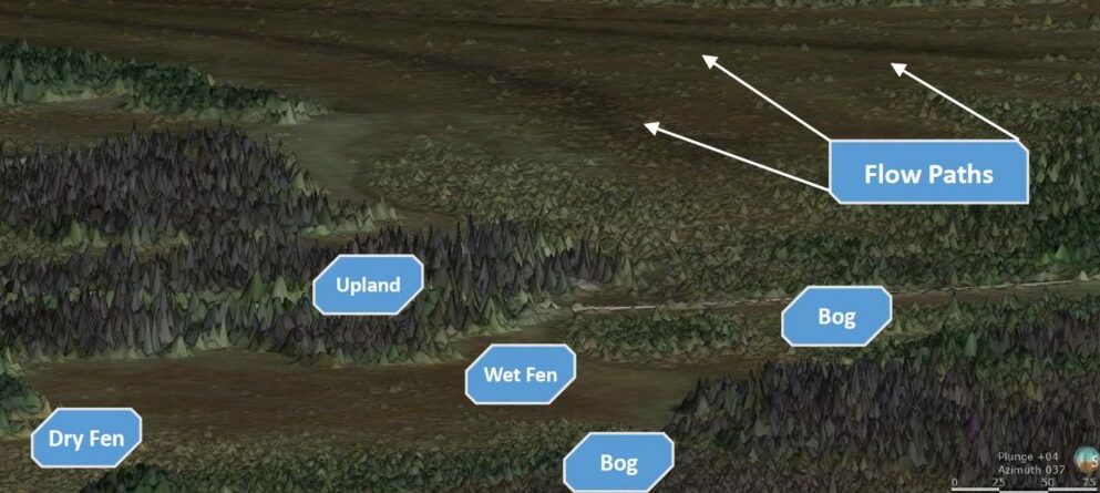
Wetlands are among the most valuable ecosystems on Earth, playing a crucial role in preserving global biodiversity, providing drinking water, minimizing flood risk, preventing wildfires, and mitigating climate change. These ecosystems are essential for maintaining environmental balance and supporting a wide array of plant and animal life. However, there is a pressing need to implement emerging scientific tools to further understand the complex processes governing boreal peatland evolution, hydrogeology, ecology, and geochemistry. Advanced technologies and methodologies are vital for gaining deeper insights into these dynamic environments and for developing effective conservation and management strategies.
Fluvial engineers and geoscientists have significant expertise in analyzing wetland hydrology through a holistic system approach that integrates surface water and groundwater interactions. This comprehensive method was initially developed within academia, using case studies in the Alberta boreal forest, and has since been successfully implemented in various projects across the province. By combining academic research with practical application, these professionals are able to address the unique challenges of wetland ecosystems and contribute to their preservation and restoration. Their work not only enhances our understanding of wetland dynamics but also supports the sustainable management of these vital natural resources.
TERRAIN DATA COLLECTION AND ANALYTICS

Fluvial Engineering Inc. offers specialized services in creating highly accurate three-dimensional models, digital elevation models (DEMs), and orthophotos for river valleys, watersheds, geohazard assessments, and terrain stability analysis. Utilizing advanced technology such as the DJI Matrice 350 RTK drone, equipped with the Zenmuse L2 LiDAR sensor and DJI Terra software, our team captures detailed spatial data essential for environmental and engineering projects. The DJI Matrice 350 RTK provides unparalleled precision with its real-time kinematic positioning, ensuring that the data collected is both accurate and reliable. The Zenmuse L2 enhances this capability with its high-resolution LiDAR sensor, capable of penetrating vegetation to reveal the true ground surface, making it ideal for complex terrains like river valleys and forested watersheds.
By processing the collected data with DJI Terra, Fluvial Engineering Inc. transforms raw data into comprehensive digital models and orthophotos. These models are invaluable for conducting detailed geohazard assessments, analyzing terrain stability, and planning mitigation strategies. Our services provide clients with actionable insights and visualizations that support informed decision-making in environmental management, infrastructure development, and disaster risk reduction. Whether for monitoring erosion, planning restoration projects, or assessing potential landslide risks, our cutting-edge technology and expertise ensure that our clients receive the most accurate and useful geospatial information available.
POND AND SPRING MANAGEMENT
Fluvial Engineering Inc. leverages cutting-edge geoscience technology to offer comprehensive solutions for assessing and enhancing the hydrology of agricultural ponds and springs. Utilizing advanced tools and techniques, such as remote sensing, LiDAR, and GIS modeling, our team conducts detailed analyses to understand the water flow, storage, and quality of these vital water resources. By accurately mapping hydrological features and identifying potential issues, we provide actionable insights that help optimize the management and sustainability of ponds and springs.
Our services are designed to improve pond water health and support the restoration and preservation of riparian ecosystems. By analyzing the interactions between surface water and groundwater, sediment transport, and nutrient cycling, we develop tailored strategies to mitigate pollution, reduce sedimentation, and enhance water quality. These measures not only benefit the pond and surrounding ecosystems but also contribute to the broader environmental health of the area. We work closely with stakeholders to implement best management practices that promote biodiversity, stabilize banks, and create habitats for wildlife.
For growers, producers, farmers, and conservation land managers, Fluvial Engineering Inc. provides viable irrigation solutions that ensure a reliable water supply. Our hydrological assessments inform the design and implementation of efficient irrigation systems that maximize water use efficiency and reduce wastage. By integrating modern irrigation technologies with our geoscience expertise, we help clients achieve sustainable water management, improve crop yields, and support long-term agricultural productivity. Whether for small-scale farms or large conservation projects, our services deliver practical and environmentally sound solutions tailored to meet the specific needs of each client.